A Photographer's Playground from the Air
Western Australia's South West region is one of the most visually diverse landscapes you can photograph from a drone. Within a 200-kilometre radius, you move from towering karri forests to dramatic coastline, from vineyard-covered valleys to wide agricultural plains. Each environment presents unique aerial photography opportunities and challenges that reward experienced operators and challenge beginners.
The region from Busselton to Albany encompasses some of Australia's most iconic natural features. Margaret River's wine country, the Leeuwin-Naturaliste coast, the Valley of the Giants, Walpole-Nornalup National Park, and the stunning beaches of Esperance to the east. The aerial perspectives across this region are world-class, and the relatively sparse population means fewer airspace restrictions compared to Perth.
Coastal Photography: Where Land Meets Ocean
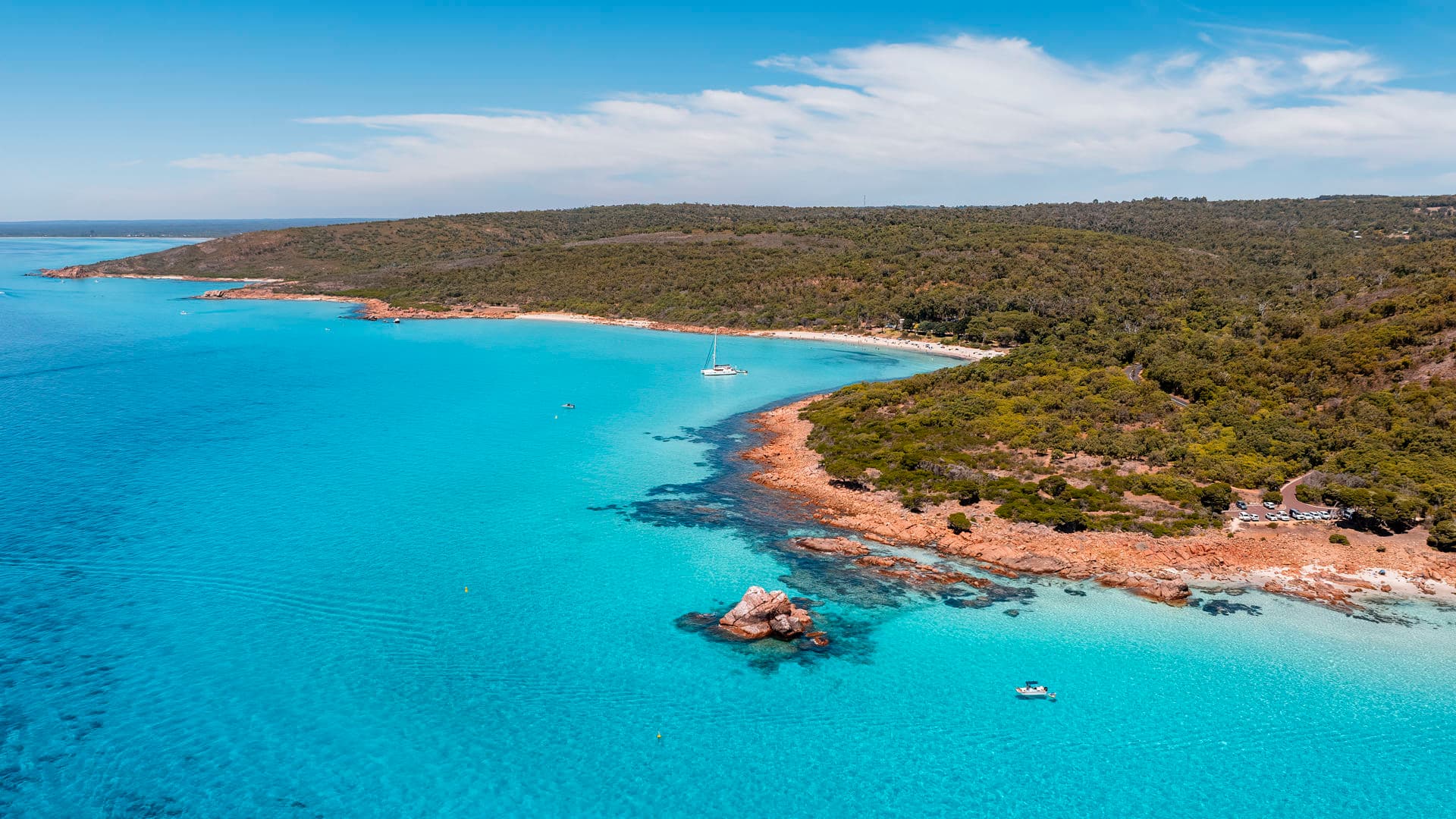
The South West coast offers aerial photography opportunities that rival anywhere in the world. The turquoise water at Meelup Beach. The granite formations at Canal Rocks. The dramatic cliffs of the Gap near Albany. The endless white sand at Twilight Beach. Each location presents a unique interaction between land and ocean that is only fully appreciated from above.
Wave patterns, reef formations, and colour gradients in the water create natural compositions that require minimal intervention from the photographer. The key is timing. Early morning provides calm water and golden light. Midday reveals the full range of water colours as the sun penetrates to different depths. Late afternoon adds warm tones and long coastal shadows. Each time of day produces a fundamentally different image from the same location.
Be aware of marine park restrictions. Several South West coastal areas fall within marine parks that have specific drone regulations. Check with Parks and Wildlife WA before flying, particularly around Ngari Capes Marine Park and the Fitzgerald River National Park.
Wine Country from Above
Margaret River's vineyard landscape is stunning from altitude. The geometric rows of vines create patterns that change with the seasons. Spring brings fresh green growth. Summer shows full canopy. Autumn adds gold and red tones. Winter reveals the bare structure of the vines against dark soil. A vineyard photographed across four seasons tells a complete visual story of the wine-making cycle.
For winery clients, aerial photography serves both marketing and operational purposes. The marketing value is obvious. An aerial image showing the vineyard, the cellar door, and the surrounding bush creates a lifestyle proposition that ground-level photos cannot match. Operationally, aerial imagery helps viticulturists assess canopy health, irrigation coverage, and growth patterns across the property.
Forests and National Parks
The tall timber country of the South West presents unique aerial challenges. Karri and tingle forests create a dense canopy that limits what you can see from directly above. The most compelling forest aerial shots come from oblique angles that show the height of the trees, the depth of the forest, and the interaction between the canopy and the sky. Dawn and dusk light filtering through the forest canopy creates atmospheric conditions that photograph beautifully.
National parks have specific drone regulations. Some parks prohibit drones entirely. Others allow them in designated areas with permits. Always check with the Department of Biodiversity, Conservation and Attractions before planning a flight in any national park or nature reserve. Compliance is not optional, and the fines for unauthorised drone use in protected areas are significant.
Planning a South West Aerial Photography Trip
The South West covers a large area. Plan your trip around specific locations and lighting conditions rather than trying to capture everything in one visit. A focused three-day trip targeting coastal locations, vineyard country, and forest environments at optimal times of day will produce far better results than a rushed attempt to hit every location.
Check CASA airspace restrictions for each location. Most of the South West has minimal controlled airspace, but temporary restrictions for emergency services, particularly during bushfire season, can appear without notice. Monitor NOTAMs daily during your trip. For professional aerial coverage of South West locations for tourism, property, or commercial purposes, explore our services or get in touch.